


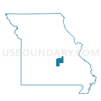
Doolittle Outside Voting District, Phelps County, Missouri
About
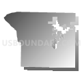
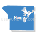
Outline

Summary
| Unique Area Identifier | 609378 |
| Name | Doolittle Outside Voting District |
| County | Phelps County |
| State | Missouri |
| Area (square miles) | 35.37 |
| Land Area (square miles) | 35.21 |
| Water Area (square miles) | 0.15 |
| % of Land Area | 99.57 |
| % of Water Area | 0.43 |
| Latitude of the Internal Point | 37.92172320 |
| Longtitude of the Internal Point | -91.92324870 |
Maps


Graphs
Select a template below for downloading or customizing gragh for Doolittle Outside Voting District, Phelps County, Missouri


Neighbors
Neighoring Voting District (by Name) Neighboring Voting District on the Map
- Cold Springs West Voting District, Phelps County, MO
- Doolittle Ward No. 1, Phelps County, MO
- Doolittle Ward No. 2, Phelps County, MO
- Doolittle Ward No. 3, Phelps County, MO
- Jerome Voting District, Phelps County, MO
- Liberty East Voting District, Phelps County, MO
- Liberty West Voting District, Phelps County, MO
- Miller West Voting District, Phelps County, MO
- Newburg Ward No. 1, Phelps County, MO
- Newburg Ward No. 2, Phelps County, MO
- Rolla Outside North Voting District, Phelps County, MO
- Rolla Outside South Voting District, Phelps County, MO
Top 10 Neighboring County Subdivision (by Population) Neighboring County Subdivision on the Map
- Rolla township, Phelps County, MO (17,696)
- Miller township, Phelps County, MO (3,734)
- Arlington township, Phelps County, MO (2,289)
- Cold Spring township, Phelps County, MO (2,174)
- Liberty township, Phelps County, MO (355)
Top 10 Neighboring Place (by Population) Neighboring Place on the Map
Top 10 Neighboring Unified School District (by Population) Neighboring Unified School District on the Map
- Rolla 31 School District, MO (30,939)
- Dixon R-I School District, MO (6,436)
- Newburg R-II School District, MO (2,888)
Top 10 Neighboring State Legislative District Lower Chamber (by Population) Neighboring State Legislative District Lower Chamber on the Map
Top 10 Neighboring State Legislative District Upper Chamber (by Population) Neighboring State Legislative District Upper Chamber on the Map
Top 10 Neighboring 111th Congressional District (by Population) Neighboring 111th Congressional District on the Map
Top 10 Neighboring Census Tract (by Population) Neighboring Census Tract on the Map
- Census Tract 8905, Phelps County, MO (3,852)
- Census Tract 8907, Phelps County, MO (3,127)
- Census Tract 8906, Phelps County, MO (3,029)